Grand Teton National Park Trails & Maps, Trail Guide

Photo © iStockPhoto

Photo © iStockPhoto

Photo © BJ Hansen - AllTrips.com
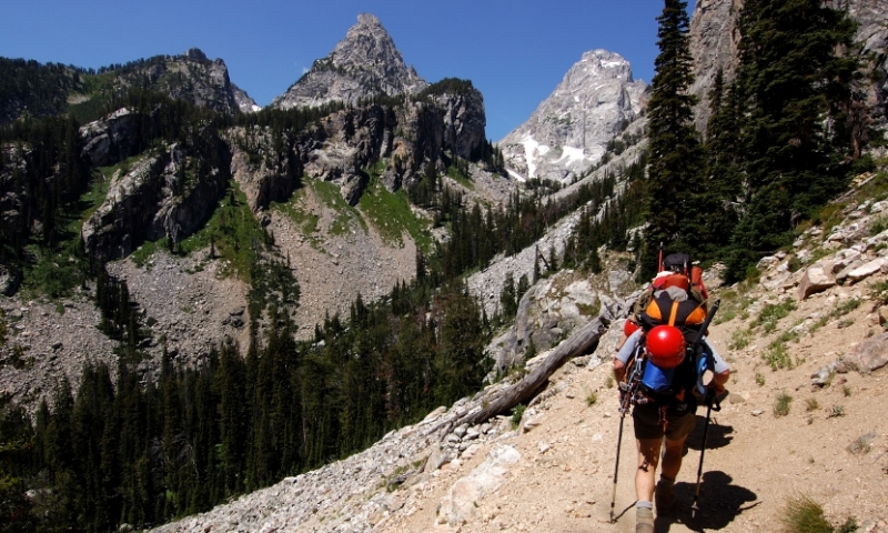
Photo © iStockPhoto

Photo © Tim Bradshaw - AllTrips.com

Photo © Lisa Ridenour - AllTrips.com
The over-200 miles of hiking trails in Grand Teton National Park offer access to backcountry lakes and streams, glacial-cut canyons and pristine backcountry camping.
One of the best ways to experience the alpine aura of Grand Teton National Park is to hike its trails, surrounding yourself with the deep canyons, rugged mountains and alpine lakes that have made it famous. Trail difficulty levels range from easy to strenuous and from short strolls to multi-day excursions, ensuring that there’s a trail for everyone.
Below, you’ll find a brief overview of some of the Park’s best hiking areas, with additional information available by following the navigation links above. You’ll also find some tips on planning your trip and getting here.
Cascade Canyon
There may not be a better way to start a trip in Grand Teton National Park than taking a boat across Jenny Lake and climbing past Hidden Falls to Inspiration Point.
Granite Canyon
Just north of Jackson Hole Resort, Granite Canyon is famed for its winter skiing. In summers, the canyon provides longer hikes to and from the top of the Tram and String Lake.
Pacific Creek Area
This area is great for moderate backcountry hikes through forests, up mountains and to scenic lakes.
Death Canyon
One of the less-popular areas on Grand Teton National Park, Death Canyon is an ideal way to access Alaska Basin and Death Canyon Shelf.
Jackson Lake
The Jackson Lake area is perfect for short, easy hikes around the lake’s mirrored images of the Tetons.
Paintbrush Canyon
Paintbrush Canyon offers a challenge for advanced hikers looking to put in some miles on their way to String or Holly Lake.
Garnet Canyon
The standard approach to the South, Middle and Grand Tetons, Garnet Canyon is great for a day hike, an overnight or a staging ground to summit one of the Tetons.
Northern Tetons
Some of the more challenging hikes around Grand Teton National Park can be found in the Northern Tetons.
Teton Canyon
The western side of the Tetons is often overlooked, leaving this beautiful area free of crowds.
Teton Crest Trail
Perhaps the ultimate backpacking experience in the Tetons, the Teton Crest Trail tours you through the entirety of this stunning range.
Planning Ahead
If you plan on doing any amount of hiking in or around Grand Teton National Park, you should be prepared for all types of weather. During the summer months, days often begin clear before afternoon thunderstorms roll in quickly, giving few warnings before they are right overhead. Try to plan your hike so that you are on your way back down by noon.
Daytime summer temperatures range between 70 and 90 degrees. June can be cool and rainy, and high water from spring runoff can offer some hazards in stream crossings and trail quality. The peak summer months, July and August tend to be drier.
Visitor centers at Moose and Colter Bay provide information, audiovisual programs and exhibits on the park. Consult rangers and park workers for current conditions and wildlife sightings before venturing into the backcountry. Local gear shops in Jackson, Wilson and Moose are also valuable sources of information or any last-minute items you may need.
Any overnight trip in Grand Teton National Park requires a permit (available at the ranger stations) and bear-proof canisters for food.
Getting There
There are four entrances to Grand Teton Nation Park. At the southern end, Granite Canyon Entrance can be found just north of Teton Village and Jackson Hole Resort off of the Moose-Wilson Road. The Moose Junction Entrance, just north of there, is off of Hwy-191, 12 miles north of Jackson. Moran Junction Entrance is 18 miles north of Moose Junction along Hwy-191, near Jackson Lake. The northernmost entrance to the Park is through the South Entrance of Yellowstone National Park, along Hwy-89.
The nearest airports are in Jackson, Wyoming and Idaho Falls, Idaho. Both airports have car rentals.


